|
Caernarfon Town Walks
 |
|
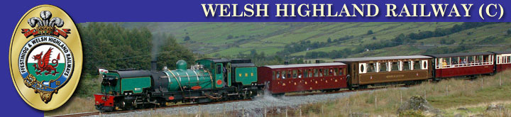
Bwlch Cwm Llan (© Walker
Eryri) |
|
|
Distance - various
Duration - various
Grade – Easy
(
PDF of various town walks )
Caernarfon – Dinas via the Lon Eifion track.
Distance – 2.5 miles
Duration - 1 hour
Grade – Easy
A simple walk/cycle along the Lon Eifion track alongside the
railway.
(
Full details
here )
Caernarfon to Waunfawr.
Distance – 5.5 miles
Duration – 3-4 hours
Grade – Easy
A straightforward and pleasant walk through the wooded Gwyrfai
valley, with views over the Arfon plain from the flanks of Moel
Smytho.
(
Full details
here )
Dinas via Rhostryfan and parts of the Bryngwyn Branch trackbed to
Bontnewydd.
Distance - 7 miles
Duration - 5 hours
Grade – Easy
An easy walk with little climbing that takes in parts of the
Bryngwyn branch.
From the station, take the flat Lon Eifon track north, back towards
Caernarfon for about 600m before turning across the railway and
continuing to the main road. Cross the road (with care!) and take
the minor road opposite south-east. At the end of the row of houses
on the right hand side, the road bears left and a footpath is
available at this bend. Take this towards Plas Bodaden, where you
cross the railway again. There is then a slight climb up to Tyn–y-weirglodd,
where the path turns south-west and meets a minor road heading due
west. About 50 yards along this road there is a crossroads, head
kind of straight on and a little left onto the minor road heading
south-south-west.
In 400 metres at a meeting of paths and the end of this minor road,
head straight on (south-south-east). After 300 metres or so, turn
off this road/track left heading south-east towards Cae-Morfydd.
Here you meet another minor road. Turn right and in 50m, left onto a
path heading east. In approx 200m turn left and north. At the next
buildings (300m), turn right, east and in approx 400m you will meet
the trackbed of the old NWNGR Bryngwyn route. There are signs on
this old trackbed explaining the history of the Bryngwyn branch.
Take a left onto this trackbed and continue until you enter the edge
of Rhostryfan and a minor road, turn right and follow this minor
road to the main road through the village.
Here turn left and in 75m turn right onto a path heading north-east,
in 200m turn left heading west and follow the path as it bends
northwards towards Hafodty Wernlas. In approx 1Km turn left and
north downhill. In 200m this meets another path heading north-west,
turn left to follow this to the minor road, crossing the old
trackbed again in the process. If you turn left on this road you
would meet the WHR in 100m, but we are going right. Head due east
for just over 1Km and then turn left and north towards Tan-yr-Allt
and cross the railway before turning left (west) alongside it. The
track then climbs away from the railway through woods and meets a
bridge over the Afon Gwyrfai. Here take a path north and after 200m
turn left (west) towards Plas Glan-yr-Afon.
In 800m once past Plas Glan-yr-Afon and Ty-gwyn, turn left onto a
zig-zag path towards Bontnewydd. On entering the village (Dol Pandy
farm) turn left onto the road, right onto the A487 north for 50m and
then left again. At the fork, take the left road towards the
station, which is in 200m on the right.
Waunfawr to Snowdon Ranger.
 |
|
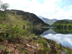
Snowdon from Mynydd Mawr
(© Walker Eryri) |
|
|
Distance - 7 miles
Duration - 5 hours
Grade – Moderate
A challenging walk between that gives great views of Llanberis and
the mountains surrounding Snowdon.
Take the station footbridge into the car park and turn right onto
the main road, crossing the railway on the main bridge. Continuing
on the road, you cross the Afon Gwyrfai, before a path appears on
the right, heading north-east. This takes you to a minor road, turn
right and then first left. After 50m, close to the junction with a
minor road, a path leads east on the right hand side. This climbs up
east and then north-east through fields towards the woods at Donen
Las (approx 1Km away).
Continuing through these woods, just as you appear back into open
land, bear right onto a path heading east towards Bwlch-y-Groes
quarry. Carry on to Maen Llwyd Isaf and here turn left (east) onto a
minor road/track before taking the first right in 50m. This path now
heads south-east and crosses the Afon Goch and then, in 1Km the Afon
Hwch, before heading almost due south.
Skirt the edge of Ty n-yr-aelgerth and climb south up the valley
between Foel Goch on your right and Moel Cynghorion on the left.
After reaching the summit at Bwlch Maesgwm head south downhill and
in approx 600m, take the right path at the crossroads, heading west.
This then zig-zags down the rest of the height and takes you to
Snowdon Ranger station.
Snowdon Ranger – Glan-yr-afon quarries - Rhyd Ddu
Distance - 3 miles
Duration - 3 1/2 ho
Grade – Moderate
A fairly simple walk taking in the foothills of Snowdon and the
Glan-yr-afon quarries on the way to Rhyd Ddu.
From Snowdon Ranger station, take the Snowdon Ranger path, heading
north-east past Llwyn Onn and up the zig zag path to the meeting of
main paths in just over 1 Km. Here carry straight on east and just
after you enter the open access land a path leads right and
south-east. This path bends to head due south downhill and after
crossing the Afon Treweunydd in 1Km, it traces the edge of the
Glan-yr-afon quarries (one of the reasons for building the NWNGR to
Rhyd Ddu in the first place, before it became part of the WHR). The
path then heads east up the quarry incline before turning off
heading first south, then east, then south-west. This leads to
Clogwyn-y-Gwin and down to a crossing of the WHR. From here, the
path heads south-west to Rhyd Ddu village and a short walk up the
main road takes you to the station.
Snowdon Ranger path up Snowdon
Distance - 7 miles return
Duration - 5 hours
Grade – Moderate
This path, named after John Morton, the self-styled "Snowdon
Ranger", who lived in what is now the Youth Hostel is perhaps the
earliest route up Snowdon, and is probably similar to that taken by
the men from the Copper Mine in Cwm Dyli, who manhandled the ore up
to Bwlch Glas and then dragged it by sled to the shores of Llyn
Cwellyn.
( Full details
here )
Rhyd Ddu path up Snowdon
Distance - 8 miles return
Duration - 6 hours
Grade – Moderate
The classic route up Snowdon from Rhyd Ddu taking in the mighty edge
of Bwlch Main (safe in normal conditions, but in snow and ice
conditions, however, it can be very dangerous, and should only be
attempted by experienced mountaineers with the proper equipment.)
( Full details
here )
Rhyd Ddu - Nantlle Ridge circular
 |
|
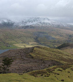
View along the Nantlle
Ridge (© Walker Eryri) |
|
|
Distance – up to 10 miles (can turn around earlier)
Duration - up to 8 hours
Grade – Hard
A fabulous walk and scramble with beautiful views, but a walk only
for the experienced hill-walker.
( Full details
here )
Yr Aran from Rhyd Ddu circular
Distance – 6 miles
Duration - 4 hours
Grade – Moderate
A moderate climb up to Yr Aran from Rhyd Ddu and at only 4 hours,
it's a perfect afternoon walk.
(
Full details
here )
Rhyd-Ddu and Y Garn Walk
Distance – 6 miles
Duration - 4 hours
Grade – Hard
Take in the best scenery around Rhyd Ddu, a disused quarry and
forest tracks in this hard, but enjoyable walk. A walk only for the
experienced hill-walker.
(
Full details
here )
Please Note:
The details given in all these walks and the links provided are for
information only. The Festiniog Railway Company will not be held
liable for mistakes in the above walks, although it has made its
best endeavours to ensure they are accurate.
Intending walkers should ensure that they have the correct kit
(especially decent boots, a map, food/drink and waterproofs) before
they set off. Be aware that the weather can change very quickly in
the mountains and a sunny day can soon turn to driving rain and
mist.
It is hoped that walkers will always follow the country code and
show respect for landowners, livestock and the environment.
|